
How to Plan a Realistic Visit to Siesta Key’s Rocky Shore
Beach Access 13 is practical only after confirming how to reach it without leaving a vehicle where parking is prohibited or unauthorized.
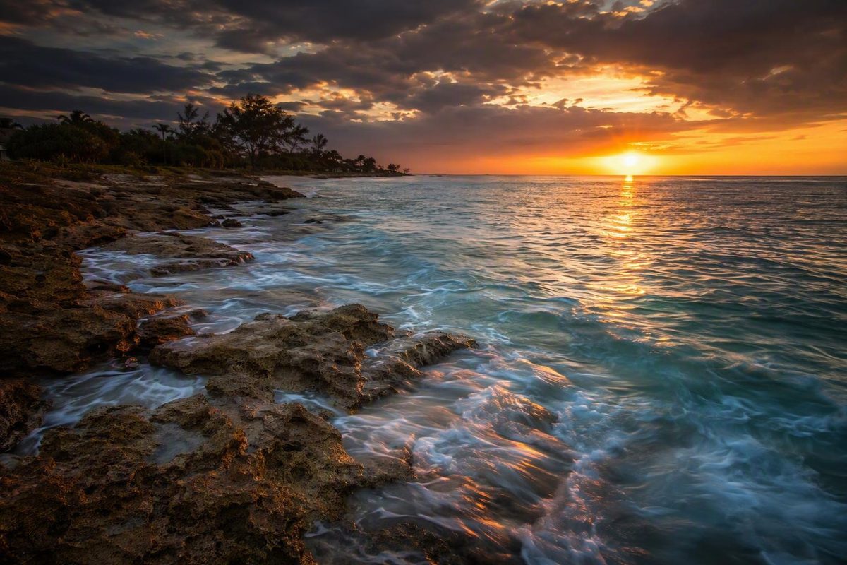
Point of Rocks on Siesta Key is not a conventional beach attraction. At the southern end of Crescent Beach, a beachrock outcrop follows the shoreline and extends into the Gulf, creating shallow ledges, crevices, and intertidal areas. Shore snorkeling is the main draw, but visitors also come to explore exposed rocks, fish, photograph the coast, look for shells, paddle, or walk the beach.
The appeal is real, but so are the limitations. Nearby public parking is scarce, facilities at the formation are minimal, and published access information comes largely from third-party guides rather than current official listings. Clear-water photographs do not show what the same shoreline may look like after rain, during rough surf, or when waves stir sediment from the bottom.
Treat Point of Rocks as a condition-dependent shoreline stop rather than a guaranteed snorkeling attraction. Choose a recognized public access, settle your parking plan before entering the surrounding residential area, inspect the water from shore, and be prepared to substitute a beach walk or low-water observation when conditions are unsuitable.
Point of Rocks at a Glance: Location, Character, and Expectations
Point of Rocks lies at the southern end of Crescent Beach on Siesta Key. Its defining feature is a beachrock outcrop running along and into the Gulf shoreline. Depending on water level, some ledges may be exposed while others remain under shallow water.
A local publication describes the site as an intertidal beachrock area used for snorkeling, diving, fishing, and low-tide exploration—not as a developed reef park or boat-diving destination (Siesta Sand’s Point of Rocks overview).
Entry is from shore, and the underwater interest comes from moving around shallow ledges, openings, and uneven rock rather than swimming over a large tropical coral reef. Other activities associated with the area include:
- Observing exposed rock and intertidal crevices at lower water
- Beach walking and shelling
- Fishing where access and current rules allow
- Coastal and sunset photography
- Bird-watching
- Diving for properly trained and equipped visitors
- Paddling in appropriate weather and from a confirmed lawful launch
- Occasional surfing during suitable swell
The critical variable is conditions. Point of Rocks may provide an enjoyable shallow-water outing when the Gulf is calm and reasonably clear. It may also be cloudy, rough, or less substantial than a visitor expects. Individual reports range from enjoyable snorkeling with visible fish to breaking waves, poor clarity, and unfavorable comparisons with the Florida Keys.
Those accounts can all be genuine. They may simply reflect different combinations of wind, wave energy, tide, recent rain, suspended sediment, and water-quality conditions.
Tide affects how much rock is exposed or submerged, but it cannot predict the entire experience. Waves may stir bottom sediment, wind may generate chop, and rain or storms may be followed by reduced clarity or water-quality concerns. A sunny sky alone does not establish that the water is suitable for entry.
Access is another central constraint. This is not a large public beach complex where drivers can assume abundant spaces, an obvious entrance, concessions, and equipment services. The approaches repeatedly described in local guides are small public access points within a residential and commercial area.
Point of Rocks is most appealing to visitors interested in unusual shoreline geology, shallow exploration, or flexible beach recreation. It is a weaker choice when a trip depends on guaranteed parking, predictable visibility, extensive facilities, easy mobility access, or reliable wildlife sightings.
Driving There: Beach Access 12, Beach Access 13, and Parking
Point of Rocks and its public approaches are not the same place. Online addresses may identify Beach Access 12, Beach Access 13, a Crescent Beach listing, or the general vicinity rather than the precise position of the exposed or submerged formation.
The following comparison summarizes recurring third-party descriptions, not confirmed real-time county information:
| Public access | Commonly published vicinity | Recurring description | Important uncertainty |
|---|---|---|---|
| Beach Access 13 | Near 6900 Point of Rocks Road | Closest pedestrian-oriented approach | Third-party guides report no public parking at the access |
| Beach Access 12 | Near 6490 Midnight Pass Road | Parking-oriented approach followed by a walk south along Crescent Beach | Parking is limited, and published capacity estimates conflict |
The addresses and operational details should be checked against current Sarasota County information and on-site signs before travel. No particular parking space, access status, route condition, or operating schedule is guaranteed.
Beach Access 13: the walk-in-oriented approach
Beach Access 13 is commonly listed near 6900 Point of Rocks Road and described as a public pathway between residential properties. Third-party sources generally present it as the closest pedestrian approach to Point of Rocks but not as a place where visitors can park (Siesta Key beach-access parking guide).
Do not drive onto Point of Rocks Road expecting spaces beside the walkway. Access 13 is practical only if you have already confirmed how you will reach it without leaving a vehicle where parking is prohibited or unauthorized.
A ride-service or drop-off plan also requires current verification. The available evidence does not establish a designated loading area, a safe place to wait, or current traffic restrictions at the access.
Beach Access 12: the parking-oriented approach
Beach Access 12 is commonly listed near 6490 Midnight Pass Road. Third-party accounts repeatedly describe it as the practical approach for visitors arriving by car. From the access, visitors reach Crescent Beach and proceed south along the beach toward Point of Rocks.
Published descriptions of the lot conflict. One guide reports 13 spaces, while other sources and a visitor video describe approximately 20. Because none of those figures is confirmed here by current official information, plan around the only dependable conclusion: the lot is small.
Arriving early may improve the chance of finding a legal space, particularly during busy periods, but it cannot guarantee one. A photograph, review, or video from an earlier year does not establish present capacity, restrictions, hours, or availability.
Rules for parking without creating a residential problem
Use a conservative parking standard:
- Follow current signs rather than old online directions.
- Use only spaces clearly designated for public parking.
- Do not block driveways, gates, service access, or traffic lanes.
- Do not assume an unmarked roadside area is public parking.
- Do not use residential, condominium, lodging, restaurant, or shopping-center parking without current authorization.
- Do not wait in a travel lane for a space to open.
- If a posted instruction conflicts with an online guide, follow the posted instruction.
A third-party parking guide likewise advises visitors not to use private or resident parking and not to block driveways. Because it is not an official county source, its access counts and transportation details still require current confirmation.
Some personal accounts propose climbing around seawalls, passing beside homes, or wading through water to reach other parts of the formation. Do not treat those descriptions as public-access directions. The supplied evidence does not establish the present legality, property boundaries, water depth, or safety of those routes.
What to do when Access 12 is full
No specific backup lot close to Point of Rocks has been verified by the supplied evidence. That means the backup must be researched before departure rather than improvised on residential streets.
Possible plans include:
- A larger public beach lot whose current hours, restrictions, and onward walking or transit connection you have confirmed
- Current public transportation with a verified stop, schedule, and practical walking connection
- A ride service with a confirmed lawful pickup and drop-off arrangement
- Another beach or non-water activity
Do not assume an old trolley description remains current. Third-party sources provide inconsistent or incomplete transportation information, and they do not establish exactly where a current service would leave a visitor relative to either access.
If Access 12 is full and no verified alternative is ready, change plans.
When to Visit: Tide, Wind, Waves, Rain, and Water Quality
The evidence does not establish one universally best tide for Point of Rocks. Several commercial guides favor high or incoming water for snorkeling because more ledges are submerged. Another recommends low to mid-tide for viewing. The useful response is to match water level to the intended activity rather than search for one perfect tide.
Match water level to the activity
Higher or rising water may cover more ledges and provide enough depth to snorkel over areas that would otherwise be exposed or too shallow.
Lower water may reveal more beachrock, crevices, and intertidal areas. That can favor photography and careful observation from stable shoreline footing. It may also leave too little water over parts of the formation for comfortable snorkeling.
Neither water level is inherently safe. Lower water exposes rough and potentially slippery surfaces; higher water can conceal those same surfaces and allow waves to wash farther across the ledges.
Tide cannot predict visibility by itself
Visibility also depends on:
- Wind and local chop
- Breaking waves
- Sediment stirred from the bottom
- Recent storms
- Recent rain
- Available light
- Water-quality events
Commercial descriptions place observed visibility anywhere from only a few inches to approximately 20 feet under favorable conditions. That range is not a forecast. It illustrates why visitors should plan for uncertainty rather than the upper figure (Peppertree Bay’s visibility discussion).
Early morning is a sensible planning window because parking may be easier and wind may be lighter than later in the day. It remains only a planning preference. Morning can still bring swell, storms, cloudy water, or a water-quality problem.
A three-level decision framework
Proceed
Consider entering only when:
- The water appears calm from shore.
- You can see enough of the entry area to place your feet deliberately.
- Waves are not breaking forcefully over the rocks.
- A simple return to ordinary beach shoreline remains available.
- There is no known weather, closure, or water-quality reason to avoid entry.
- Every swimmer is comfortable with the conditions actually present.
Use caution or switch activities
Stay ashore or choose conservative shoreline observation when:
- Visibility is marginal.
- Repeated waves are washing over exposed surfaces.
- The bottom is difficult to read.
- Returning would require crossing rock in breaking water.
- Anyone in the group is uncertain, tired, overheated, or uncomfortable.
A beach walk, shell observation, photography, or viewing exposed ledges may be a better use of the visit.
Postpone water entry
Do not enter when:
- Waves are breaking over the formation.
- A storm or lightning threat is developing.
- A water-quality warning or beach advisory applies.
- The water is too opaque to assess the entry and return route.
- A swimmer cannot maintain an easy path back to shore.
- Conditions exceed the ability of the least capable person in the group.
On the day of the visit, consult current official tide predictions, marine weather, wind and wave information, red-tide reporting, water-quality notices, and beach advisories. The supplied research does not include verified live links for those tools, so use the relevant current government or agency pages rather than a commercial forecast copied into an older guide.
Snorkeling Point of Rocks: Depth, Visibility, Gear, and Marine Life
Snorkeling at Point of Rocks is a shore-entry experience around shallow ledges and crevices. It is not equivalent to a boat trip over a tropical coral reef, and expectations should reflect that difference.
Commercial guides describe parts of the area as reaching roughly six feet of water, but that is a reported estimate rather than a guaranteed maximum. Tide changes the water level, and the bottom is uneven. Shallow water may still contain abrupt variations, holes, or difficult footing.
Reported visibility ranges from extremely poor to approximately 20 feet in favorable conditions. No source can promise the upper figure for a particular visit. A visitor video uploaded in 2022, for example, showed the site and reported abundant rocks and sea life but reduced visibility during a wavy visit (Justin’s 2022 Point of Rocks snorkeling video).
What to bring
A compact setup is easier to manage around uneven terrain than unnecessary or unfamiliar equipment.
Mask and snorkel: Use a mask that seals correctly and a snorkel you have already tested. Equipment problems are harder to solve while balancing near wet rock.
Fins: Fins are optional. Put them on only from a position where you can remain stable.
Secure water shoes: Footwear with traction is one of the most consistently recommended items. Personal accounts describe sharp, wet, and slippery terrain, including crevices and holes that may be concealed by shallow water (local fishing author’s terrain account).
Sun protection: Bring protective clothing, a hat for shore time, and suitable sunscreen. Do not assume shade will be available near the formation.
Drinking water: Carry your own supply, especially in warm weather.
Dry storage: Secure keys and essential items in a dry bag or similar container. Leave unnecessary valuables elsewhere rather than creating belongings that must be watched from the water.
Wetsuit, if useful: A wetsuit may improve comfort in cooler water, but it is not universally necessary. Water temperature, wind, personal cold tolerance, and expected immersion time matter more than a fixed seasonal rule.
Before swimming or diving away from shore, consult current Florida requirements governing diver-down warnings and determine how they apply to your activity and location. The commercial packing lists in the supplied evidence do not establish when a flag is legally required.
What you might see
Plausible observations include:
- Small fish around ledges and openings
- Crabs and other small crustaceans
- Shells
- Algae and encrusting growth
- Small organisms in protected intertidal crevices
Larger or more charismatic animals should be treated as occasional possibilities, not itinerary features. Dolphins, manatees, sea turtles, nurse sharks, octopuses, sea stars, and similar animals appear in promotional descriptions or individual accounts. Those reports do not establish how likely a future visitor is to encounter them.
Traveler reports illustrate the broader variability. Some visitors have described fish near the rocks and enjoyable beach-entry snorkeling, while others encountered rougher water, poor clarity, or an experience less substantial than snorkeling in the Florida Keys (Crescent Beach traveler snorkeling report).
The realistic expectation is a shallow Gulf environment where rock structure may attract small marine life when visibility allows. Clear water and notable wildlife are possible, not dependable.
Safety, Family Suitability, and Site Limitations
Shallow water does not automatically make Point of Rocks safe or beginner-friendly.
Hazards to anticipate
Sharp or rough rock: Exposed and submerged edges may cut unprotected feet or legs.
Slippery surfaces: Wet rock, algae, and repeated wave wash can make a ledge difficult to stand on.
Holes and crevices: Openings visible at lower water may become concealed as water rises or visibility worsens.
Changing depth: The bottom is not level. Step deliberately rather than assuming the next foothold will be at the same depth.
Breaking waves:
Reduced visibility: Cloudy water makes foot placement, route-finding, and hazard assessment more difficult.
Difficult entry and exit: A route that appears manageable on arrival may become harder if waves, water level, or fatigue change.
These terrain hazards are described in a local fishing account, while snorkeling guides also recommend water shoes because the rock can be sharp and slippery. Neither type of source substitutes for a current on-site assessment.
Bring water and sun protection, and do not let the effort already invested in reaching the site pressure you into entering unsuitable water.
Maintain a simple return route to ordinary beach shoreline. If conditions worsen, leave before moving water or exposed rock stands between you and an easy exit. Do not continue around the formation simply because it was part of the original plan.
Avoid climbing seawalls, passing through uncertain private-property boundaries, or following submerged routes from personal blogs. The available evidence describes hazardous terrain but does not establish those routes as lawful public access.
Children, beginners, and weak swimmers
The available evidence is not sufficient to declare Point of Rocks appropriate for every child, beginner, or weak swimmer. Caregivers should assess:
- Actual open-water swimming ability
- Comfort using a mask and snorkel
- Ability to recover from a flooded mask
- Present visibility and wave action
- The need for close, active supervision
- Whether suitable flotation is appropriate for the individual
- Whether the supervising adult can assist without creating another emergency
- The fact that direct lifeguard coverage at the formation has not been verified
A first snorkeling session is better held in controlled, calm conditions than forced into a rocky shoreline visit because the group has already parked and walked there. If a beginner is uneasy from shore, choose beach activities or another location.
Mobility and facilities
The supplied evidence does not establish that the route is suitable for wheelchairs, strollers, or visitors with limited mobility. Sand, narrow pathways, changing shoreline conditions, and uneven rock may all affect access. Anyone with mobility needs should obtain current information about the specific path and available facilities before traveling.
A commercial lodging guide reports no restrooms or concessions directly at Point of Rocks, but that does not establish the absence of facilities elsewhere in the surrounding area (Crystal Sands’ Point of Rocks visitor guidance). Arrive prepared rather than relying on services at the formation.
Compact bring-or-skip checklist
Bring:
- Secure water shoes with traction
- Drinking water
- Sun protection
- A fitted mask and snorkel if entering
- Condition-appropriate fins or personal safety equipment
- A towel
- Secure dry storage
- A small first-aid kit kept on shore
Skip:
- Glass containers
- Loose flip-flops
- Unnecessary valuables
- Bulky equipment that impedes balance
- Gear you have never tested
- Anything that must be left unattended
Immediately before departure, recheck access status, closures, beach warnings, weather, and water-quality conditions.
What to Do When Snorkeling Conditions Are Poor
Cloudy or rough water does not necessarily make the entire visit worthless. Point of Rocks can still work as a shoreline stop if the replacement activity suits the conditions.
Observe exposed rock at lower water
When water is sufficiently low, ledges and intertidal openings may be easier to view from shore. Remain on stable footing and avoid surfaces being washed by waves.
Look into crevices without reaching into them. Do not touch or pry loose organisms. Before collecting any shell, confirm that it is unoccupied and that collection is permitted under current rules.
Walk Crescent Beach
A beach walk requires much less from the water than snorkeling. Approach through a recognized public access, remain on the ordinary beach route, and turn around whenever heat, water level, or footing makes continuing uncomfortable.
Shelling, bird-watching, photography, and sunset viewing are commonly reported activities. None promises a particular shell, animal, or quality of light, but each supports a flexible visit.
Treat paddling and diving as separate plans
Paddling and diving are associated with the Point of Rocks area, but that does not prove that either Beach Access 12 or Beach Access 13 is a suitable or permitted launch point.
A paddling plan should independently address:
- Lawful launch and landing access
- Equipment transport
- Wind and wave forecasts
- Paddler ability
- Other water users and vessel traffic
- A safe return point
Diving requires separate attention to training, buddy procedures, equipment, visibility, diver-down requirements, and entry and exit. Shallow-water snorkeling advice is not a complete dive plan.
Surfing is occasional and specialized
Point of Rocks is not a dependable everyday surf destination. One third-party guide describes an occasional left-breaking wave over a sand-and-rock bottom and categorizes the spot for intermediate surfers (Mondo Surf’s Point of Rocks guide).
That description is condition-dependent. Forecasts, ability, current access, local etiquette, and the rocky bottom should govern the decision. A poor snorkeling day is not automatically a suitable surfing day.
Fishing can be productive but demanding
A local fishing author describes Point of Rocks as potentially productive but technically difficult because the rocky bottom frequently snags tackle. The same account warns of sharp, slippery terrain, crevices, and concealed holes.
Specific claims about productive species, tackle, casting lines, retrieves, and times of day should be understood as one angler’s experience rather than established rules for success.
Before fishing, verify current:
- License requirements
- Seasons and size limits
- Protected-species rules
- Gear restrictions
- Access permissions
- Rules affecting fishing near swimmers and other beach users
If footing, access, water, or crowding is unsuitable, choose a beach walk or another destination rather than forcing the activity.
Why the Rocks Are There: What the Geology Does and Does Not Establish
Point of Rocks is generally identified as a beachrock outcrop, and researchers have used it to investigate Siesta Key’s geological development.
A local publication summarizes a 2003 University of South Florida study titled Formation of “Beach Rock” at Siesta Key, Florida, and its influence on barrier island development. According to that secondary account, the researchers dated beach deposits to at least approximately 1,800 years ago and possibly as far back as 4,300 years (Siesta Sand’s summary of the beachrock research).
Those figures require careful interpretation. The 4,300-year value is an upper estimate associated with dated deposits, not a settled birthday for every visible part of the outcrop. Saying simply that “Point of Rocks is 4,300 years old” would erase the distinction between sampled geological material and the development of the formation as a whole.
The same local summary reports that the researchers did not establish one definitive formation process or fully explain why beachrock occurs at this location. Because the original paper has not been supplied here for direct review, the scientific discussion should remain attributed to that local summary.
Avoid categorical claims about:
- Exact composition throughout the outcrop
- A precise total length
- Uniqueness on Florida’s Gulf Coast
- One conclusively proven origin
- A fixed age for every visible rock
- Pirate-treasure stories presented as history
For visitors, the practical effect of the geology is easier to observe than its unresolved origin. Changing water level exposes or submerges ledges and crevices, creating small intertidal spaces where water, shells, algae, and organisms may collect. The same structure that makes the shoreline interesting also produces difficult footing and concealed underwater features.
A Practical Point of Rocks Visit Plan
A workable plan has three parts: verify before driving, reassess from shore, and keep an alternative ready.
The day before
Confirm through current official or agency information:
- Whether Beach Access 12 and Beach Access 13 are open
- Where legal public parking is available
- Posted hours, restrictions, and any applicable fees
- Whether a transit or ride-service plan is genuinely practical
- Tide timing for the intended activity
- Marine weather, wind, and waves
- Recent heavy rain or storms
- Red-tide and water-quality reporting
- Beach advisories or closures
- Current diver-down, wildlife, or fishing requirements that may apply
The supplied research does not verify one official page containing all of those details. Do not rely on a commercial lodging guide as a live operational source; use current county, weather, health, and wildlife-agency information appropriate to each check.
Save essential information before leaving. Parking and access decisions are easier when the backup has already been chosen.
Pack for a small, undeveloped shoreline stop
Bring:
- Secure water shoes
- A properly fitting mask and snorkel
- Fins only if they suit your ability and the entry
- Drinking water
- Sun-protective clothing and sunscreen
- A towel
- Dry storage for keys and essential items
- Any condition-appropriate personal safety equipment
Do not pack on the assumption that rentals, lockers, showers, food service, or attendants will be available at the rocks.
Choose the access deliberately
Treat Access 13 as the walk-in-oriented approach described by third parties. Do not use it as a parking destination.
Treat Access 12 as the recurring parking-oriented approach, recognizing that its small lot may be full and that published capacity figures conflict.
Neither access should be considered guaranteed until current status and on-site signs have been checked. Published addresses may identify the access vicinity rather than the exact position of the formation.
Follow an arrival sequence
- Approach the selected public access without searching residential streets for improvised parking.
- Obey all posted parking and access restrictions.
- Use the recognized public path to reach the beach.
- Inspect the water before unpacking all equipment.
- Watch several wave cycles rather than judging conditions from one quiet moment.
- Identify the easiest entry and a direct return to ordinary shoreline.
- Decide whether to snorkel, observe from shore, walk the beach, or postpone.
- Reassess continuously and leave before worsening conditions complicate the exit.
Apply a strict no-space rule
If the legal lot is full, do not improvise beside a driveway, in a private lot, or on an uncertain roadside shoulder. Move to a backup whose current rules and onward connection you have already verified, use a confirmed transportation alternative, or change destinations.
No specific nearby overflow lot has been confirmed by the supplied evidence. Planning around one without further verification would create the same problem as relying on an old parking count.
Apply an equally strict poor-conditions rule
Do not enter rough or opaque water simply because:
- You drove a long distance.
- Parking was difficult.
- Yesterday’s forecast looked better.
- A social-media photograph showed clear water.
- Other people are entering.
- This is the only open morning in the itinerary.
The conditions visible from shore are more relevant than the schedule.
Observe wildlife without interfering
Watch animals without touching, chasing, feeding, or surrounding them. Confirm current rules before collecting shells or other natural material, and do not remove living organisms.
Point of Rocks is most rewarding when approached as an unusual rocky Gulf shoreline with condition-dependent recreation. Parking, underwater visibility, gentle waves, and notable wildlife should never be assumed.
Frequently Asked Questions
Where is Point of Rocks on Siesta Key?
Point of Rocks is at the southern end of Crescent Beach on Siesta Key, where a beachrock outcrop follows and extends into the Gulf shoreline.
Third-party guides commonly place Beach Access 13 near 6900 Point of Rocks Road and Beach Access 12 near 6490 Midnight Pass Road. Those addresses refer to access vicinities rather than a guaranteed precise location for every visible or submerged rock.
Can you park at Beach Access 13?
Third-party guides describe Beach Access 13 as having no public parking at the access. Treat it as a pedestrian-oriented approach, not as a place to leave a car.
Beach Access 12 is the recurring parking-oriented alternative, but the lot is small and published estimates conflict between 13 and approximately 20 spaces. Follow current signs and verify present county information before departure.
What is the best tide for snorkeling at Point of Rocks?
There is no universally best tide. Higher or rising water may cover more ledges for snorkeling, while lower water may expose more rock and intertidal features for observation.
Tide is only one variable.
Is Point of Rocks suitable for children or beginner snorkelers?
Do not assume that it is suitable merely because commercial guides describe much of the water as shallow. Sharp or slippery rock, concealed holes, changing depth, waves, reduced visibility, and a difficult exit may challenge inexperienced swimmers.
Caregivers should assess actual swimming ability, present conditions, supervision needs, and appropriate personal safety equipment. If anyone is uncomfortable from shore, choose shoreline exploration or a more controlled swimming location.
What marine life might I see at Point of Rocks?
Small fish, crabs, shells, algae, and other intertidal organisms are plausible around the ledges and crevices. What is visible depends heavily on clarity, water level, waves, and season.
Dolphins, manatees, sea turtles, nurse sharks, octopuses, and other notable animals appear in promotional or anecdotal reports. Consider them occasional possibilities, not expected sightings.