
Where to Find PEI’s True Red-Sand Shores
Planning note: This guide distinguishes documented landscape characteristics from changeable operating details. It does not confirm current entrances, parking arrangements, facilities, lifeguard coverage, fees, accessibility features or seasonal status at Argyle Shore or Chelton Beach. Verify those details with the relevant park or tourism authority before departure.
The direct answer: start with Argyle Shore or Chelton Beach
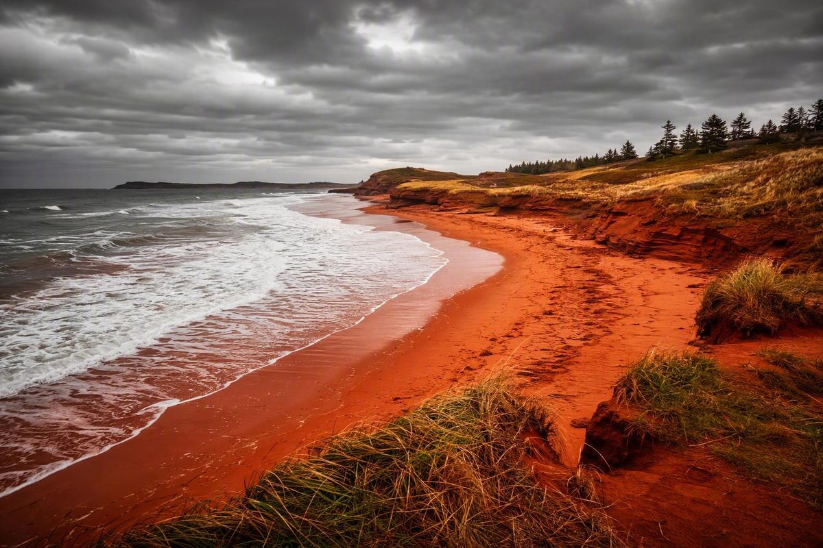
If you want literal red sand underfoot—not simply red cliffs behind a pale beach—start with Argyle Shore or Chelton Beach. Tourism PEI names both as places to see red sand in the Red Sands Shore portion of the Central Coastal Drive. That recommendation makes them the strongest documented starting points, but it is not a measured comparison proving that either has the objectively reddest sand on Prince Edward Island. Tourism PEI recommends Argyle Shore and Chelton Beach for seeing the region’s red sands.
Choose Argyle Shore if your priority is the classic south-shore combination of red sand, tidal flats and red coastal scenery. Near a useful low tide, the exposed foreground can provide a stronger sense of walking through a red landscape than a beach where the color is confined to distant cliffs.
The place name requires care. “Argyle Shore” can refer to Argyle Shore Provincial Park, while some travel accounts use “Argyle Shores” for informal or unsigned shoreline east of the park. Confirm the exact destination, entrance and permitted parking location rather than assuming that every map pin or photograph shows the provincial park.
Choose Chelton Beach if you want another documented red-sand destination associated with a day-use setting, green space and views toward the Confederation Bridge. Low tide may reveal sandbars, shallow pools and a broader red foreground. Those are landscape descriptions, not confirmation that washrooms, supervision, accessible routes or other services will be available when you visit.
A quick decision rule:
- For red sand underfoot: choose Argyle Shore or Chelton Beach.
- For an exploratory alternative: investigate Cape Egmont, but verify access and parking first.
- For dunes and a national-park landscape: choose Cavendish.
- For red sandstone formations: choose Thunder Cove.
- For a first visit: make one of the two principal red-sand beaches your main stop and plan the day around the tide.
This distinction matters because a photograph containing red rock does not necessarily show a red-sand beach. Cavendish and Thunder Cove offer dramatic red coastal geology, but stronger destination descriptions characterize their visible sand as pale or light-colored. They answer a different version of the question.
Red Sands Shore is a region, not one named beach
Red Sands Shore is a PEI travel region associated with the island’s south-central coast, not the formal name of one beach. It forms part of the Central Coastal Drive context and contains individual beaches, communities, roads, wharves, businesses and historic places. Tourism PEI describes the region as known for red-sand beaches, rolling scenery, artisans, galleries, food and cultural stops.
That regional identity explains why searching for “Red Sands Shore beach” can produce confusing results. One page may describe the scenic-drive region, another a provincial park and another an informal section of shoreline. The regional name helps define the landscape, but it does not identify a particular entrance, parking area, tide station or set of services.
For a road trip, treat Red Sands Shore as a flexible corridor rather than a fixed itinerary. Its broader appeal comes from combining a coastal stop with rolling countryside, small communities, wharves, galleries, artisan studios, food stops and historic places. There is no need to cover every attraction in one day.
Victoria-by-the-Sea is a logical companion to either Argyle Shore or Chelton Beach because Tourism PEI places it along the Red Sands Shore Coastal Drive. It offers a change of pace after the beach: a village and harbour setting, with food, galleries or other businesses depending on what is open during the visit.
Other named possibilities include Skmaqn–Port-la-Joye–Fort Amherst National Historic Site and Seacow Head Lighthouse. Either can add history or coastal scenery, but operating dates, interior access and visitor services should be checked rather than assumed.
Most importantly, conditions cannot be generalized across the region. Nearby beaches can differ in:
- The amount of sand exposed at high tide
- The firmness or muddiness of the foreshore
- The formality and location of access
- Parking arrangements
- Swimming conditions and supervision
- Seasonal services
- Posted restrictions
- Suitability for wheelchairs, strollers or visitors with limited mobility
Select the beach first. Then confirm the entrance, current notices, relevant tide prediction and conditions for that location. The regional name is useful for building the rest of the drive—not for replacing beach-specific planning.
How the main beaches compare
The key distinction is between documented red-sand candidates and pale-sand beaches framed by red geology. Evidence quality also varies: Argyle Shore and Chelton Beach are named by Tourism PEI, while Cape Egmont and Augustine Cove depend more heavily on individual travel accounts.
In the table, “strong tide influence” means that low tide is reported to reveal substantially more sand, pools or sandbars. It is not a safety rating or a prescribed arrival window.
| Beach or area | Location type | Documented sand character | Main visual draw | Best-supported reason to visit | Tide dependence | Evidence limitations | Verify before departure |
|---|---|---|---|---|---|---|---|
| Argyle Shore | South-shore destination associated with a provincial park; informal shoreline nearby is also reported | Strongly documented as red sand | Red sand, tidal flats and red coastal scenery | Low-tide walking and photography | Strong tide influence; more shore may appear as the water recedes | Some accounts describe shoreline outside the provincial park, creating location ambiguity | Exact entrance, legal parking, current park status, facilities, supervision and accessibility |
| Chelton Beach | South-shore day-use destination | Strongly documented as red sand | Red sand, pools, sandbars, green space and Confederation Bridge views | Shoreline walking and scenic day use | Strong tide influence; reported sandbars and pools are low-tide features | Amenity and swimming descriptions may become outdated | Entrance, services, parking, swimming notices, supervision and accessibility |
| Cape Egmont | Lightly documented shoreline west of Summerside | A travel writer reported deep red sand | Broad exposed sand, coastal colors and tidal pools | Exploratory walking and photography | The reported red-sand experience occurred at low tide | Public access, signage, parking rights, facilities and accessibility are not established | Permitted access, entrance, road condition, parking and local restrictions |
| Augustine Cove | Secondary south-shore possibility | Reported as red sand by travel writers | Tidal pools and low-tide shoreline | An exploratory stop if it already fits the route | Low tide is emphasized in the travel account | Less corroborated than Argyle Shore or Chelton Beach | Access, parking, rules, facilities and current conditions |
| King’s Castle Beach | Reported day-use beach on the Murray River | Described by a commercial travel guide as red sand | Riverfront sand and a day-use setting | A secondary red-sand possibility | Not established clearly enough for a categorical rating | Red-sand characterization has limited corroboration | Current access, services, rules and shoreline conditions |
| Cavendish Beach | North-shore national-park destination | More consistently described as pale or white sand, despite a 2013 visitor review calling it red | Dunes, broad sand and red sandstone cliffs | A national-park beach and dune landscape | Tide matters to any coastal visit, but red-sand exposure is not the principal draw | Visitor descriptions conflict; an old review does not establish current conditions | Parks Canada notices, surf, parking, fees, dog rules, closures and accessibility |
| Thunder Cove | Coastal beach and red-sandstone formation area | Conflicting descriptions; often presented as light sand with red cliffs | Eroded sandstone cliffs, arches and formations | Coastal-geology viewing and photography | Access near formations can become more constrained as water rises | Access descriptions vary, and erosion changes the coast | Permitted access, parking, tide, walking conditions and cliff hazards |
The classifications for Chelton, Augustine Cove, informal Argyle access, Cavendish and Thunder Cove draw partly on attributed firsthand travel reporting rather than live park information. Hecktic Travels describes the red sand and low-tide features at Chelton and Augustine Cove, distinguishes informal Argyle access from the provincial park, and identifies Cavendish as white sand backed by red cliffs.
Argyle Shore
Argyle Shore is the leading practical choice for a concentrated red coastal scene. At low tide, its visible foreground may include broad red flats, wet reflective patches and tidal textures. The surrounding red shoreline reinforces the color instead of leaving it solely in a distant cliff.
Pay close attention to the destination shown in your map application. Reports of an unsigned “Argyle Shores” location nearby should not be treated as proof of public access, maintained paths, park facilities or permission to leave a vehicle. If predictable access and services matter, verify that your directions lead to the intended park rather than an informal shoreline.
Chelton Beach
Chelton is the strongest alternative to Argyle Shore. Published descriptions associate it with red sand, low-tide sandbars, tidal pools, green space and views toward the Confederation Bridge. The bridge can become a recognizable background element, while pools and exposed sand provide foreground detail.
Chelton may suit visitors who prefer a named day-use destination over a lightly documented shoreline. That classification still does not guarantee that facilities, lifeguards or suitable swimming conditions will be available on a particular date.
Cape Egmont
Cape Egmont is an intriguing option for travelers comfortable doing additional verification. A writer for Seattle’s Travels reported deep red sand, extensive exposure and numerous tidal pools during a low-tide visit west of Summerside. That is useful firsthand evidence of the landscape, but it does not establish current public access, signage, parking rights, road condition or accessibility. Treat the Cape Egmont description as one traveler’s low-tide observation, not an official access guide.
Choose Cape Egmont only after confirming where visitors may enter and park. It is not the best first recommendation for someone who needs a clearly identified entrance or predictable visitor services.
Augustine Cove and King’s Castle Beach
Augustine Cove and King’s Castle Beach broaden the list of reported red-sand possibilities, but both deserve secondary status.
Augustine Cove’s red sand and pools are described in personal travel writing. King’s Castle Beach is described in a commercial travel guide as a red-sand day-use beach on the Murray River. The guide’s characterization supports treating King’s Castle as a possibility rather than a better-documented alternative to Argyle or Chelton.
Either may make sense if it already fits your route and current local information confirms straightforward access. Neither is the strongest choice if the entire day depends on reaching an unmistakable, well-identified red-sand destination.
Cavendish Beach
Cavendish is sometimes called a red-sand beach, including in a Tripadvisor review based on a June 2013 visit. That old account records one visitor’s impression, not a present-day classification. The dated review should not be used to establish current sand appearance, facilities, supervision or crowd levels.
Other destination and travel descriptions more consistently characterize Cavendish as pale or white sand bordered by red sandstone cliffs and dunes. Choose it for a recognizable north-shore national-park landscape, not because red sand underfoot is guaranteed.
Because Cavendish lies within Prince Edward Island National Park, its rules and operational information must not be transferred to provincial parks or informal south-shore access points.
Thunder Cove
Thunder Cove is best understood as a red-cliff and coastal-formation destination. Sources disagree about the sand itself, while its weathered red sandstone is the consistent visual attraction. Go for cliffs, arches and coastal geology rather than a promise of uniformly red sand beneath your feet.
Do not plan a visit around Teacup Rock. The formation was destroyed by Hurricane Fiona in September 2022, so photographs showing it depict a feature that no longer exists.
Thunder Cove also calls for conservative judgment around tides and cliffs. Erosion changes the shoreline, and incoming water can reduce the room available below coastal formations. Do not approach an overhang or continue along a route whose return depends on the beach remaining exposed.
Why PEI’s coast is red—and why every beach is not
Regional tourism and travel sources commonly explain PEI’s red sediment this way: iron-rich sandstone erodes into smaller material, and oxidation of the iron produces the rusty color. A regional tourism organization also says the intensity varies with the amount of iron in the material. Central Coastal PEI gives this visitor-level explanation and contrasts south-shore red sand with some north-shore white-sand beaches.
That explanation is useful for visitors, but it should not be treated as a complete scientific analysis of every beach.
The broad visual pattern described by the supplied destination sources is:
- South shore: more frequent packed red sand, broad tidal flats and red coastal sediment
- North shore: more frequent pale sand, dunes and exposed red sandstone cliffs
- Individual beaches and coves: local mixtures that may not fit either description neatly
The most important distinction is between the beach surface and the geological frame around it. A beach can have striking red cliffs but pale sand at the waterline. Conversely, a lower-profile south-shore beach may provide a more strongly red foreground even when its cliffs are less dramatic.
Cavendish illustrates the first case: pale sand and dunes framed by red sandstone. North Rustico is likewise described as white sand against red cliffs. Discover Charlottetown explicitly characterizes North Rustico’s beach as white sand set against PEI’s red sandstone cliffs. Thunder Cove’s most consistently reported attraction is its red rock, even though descriptions of the sand conflict.
Photography can blur these distinctions. If your objective is specifically to walk on red sand, use beach-level descriptions rather than photographs of red headlands alone.
Plan around low tide, not just the clock
Low tide is the most important planning variable for Argyle Shore, Chelton Beach and other south-shore red-sand locations. Regional guidance recommends it for seeing broader flats, walking more shoreline and finding tidal pools. The same guidance says high tide can cover much of the visible sand at some south-shore beaches.
Do not use a generic “PEI low tide” time. Use a current official Canadian tide-prediction service, search for the relevant coast and confirm that the selected station reasonably represents your destination. If that relationship is unclear, ask the park authority or a local visitor-information service rather than guessing.
There is no universal rule stating that a particular number of hours before or after low tide is safe. A practical sequence is:
- Find the current prediction for the relevant coast.
- Note whether the tide will be falling or rising during your visit.
- Observe the water and shoreline after arrival.
- Keep an unobstructed return route to the access point.
- Turn back before incoming water narrows the beach or pushes your route toward cliffs.
A falling tide may reveal more ground as the visit progresses. Third-party PEI coastal guidance specifically warns against depending on cliff-base access or standing beneath unstable sandstone overhangs. The same guidance emphasizes low tide for broad red flats and cautions that PEI’s soft sandstone cliffs and overhangs can be unstable.
Wear securely fastened footwear suitable for wet, muddy, slippery or uneven tidal terrain. That recommendation does not mean any beach provides a firm or accessible walking surface; assess conditions on arrival and verify accessibility separately if it is essential.
Treat tidal pools as observation areas. Small fish, crabs, snails and other organisms have been reported in them, but the available evidence does not establish local collecting rules. Watch without removing animals, overturning habitat or carrying living things away.
For photography, low tide can reveal:
- Broad red foregrounds
- Ripple patterns in wet sediment
- Reflections in shallow pools
- Exposed sandbars
- Contrasts among red shore, green vegetation and blue water
- Leading lines created by channels
None of these conditions is guaranteed. Wind, clouds, recent weather, sediment movement and the exact stage of the tide can all change the scene.
Build a flexible Red Sands Shore driving day
A practical Red Sands Shore day needs only three elements:
- One principal red-sand beach
- Victoria-by-the-Sea
- One optional coastal or historic stop
Begin by checking the tide, weather and current beach notices. Place Argyle Shore or Chelton Beach near the most useful low-tide period available, then arrange the town and optional stop around it. This is more reliable than assigning rigid times before you know what the coast will allow.
Argyle Shore version
Make Argyle Shore the anchor. Allow enough time for a shoreline walk and photography rather than treating the beach as a quick roadside viewpoint. Confirm that your directions lead to the intended entrance, especially because park and informal shoreline references can be confused.
Afterward, continue through the Red Sands Shore countryside toward Victoria-by-the-Sea. Stop where current signs, opening hours and safe parking make sense. The drive can remain worthwhile even if a particular gallery, food business or other seasonal operation is closed.
If conditions and interest permit, add Skmaqn–Port-la-Joye–Fort Amherst National Historic Site as the optional third element. Check current access and notices before making it a firm commitment.
Chelton Beach version
Use Chelton Beach as the low-tide anchor. Its red sand and possible Confederation Bridge views give it a different visual character from Argyle Shore. Continue through the Red Sands Shore region afterward, adding Victoria-by-the-Sea or a stop associated with the Confederation Bridge area if it suits your direction of travel.
Seacow Head Lighthouse is another possible addition. Confirm current access and operating information first; the presence of a lighthouse on a tourism page does not establish that its interior, café, washrooms or other visitor services will be open.
Why one principal beach is enough
Mapping applications count movement between points, not the full visit. A beach stop can involve finding the correct entrance, changing footwear, walking from parking, waiting for light, exploring exposed pools and cleaning up before returning to the car.
Trying to combine Argyle Shore, Chelton Beach and Cape Egmont may produce more driving but less meaningful time on the coast. Unless comparing beaches is the purpose of the trip, choose one principal shoreline and leave room for weather, tide changes and unplanned stops.
If rain, wind, surf, a closure or an unsuitable tide makes the beach impractical, shift the emphasis to:
- Victoria-by-the-Sea
- The regional scenic drive
- A gallery or artisan stop
- A food stop
- A wharf
- A historic site
- A safely accessible lighthouse viewpoint
The beach should anchor the route, not make the entire day dependent on one forecast.
Safety and same-day checks before leaving
Check conditions again on the morning of the visit. Saved itineraries and old reviews cannot establish current coastal conditions.
Pre-departure checklist
- Tide prediction: Use a current official prediction relevant to the correct coast.
- Tide direction: Know whether the water will be rising or falling during your visit.
- Weather: Check wind, rain, visibility and active warnings.
- Surf and swimming notices: Do not infer safe water from photographs or an old account.
- Closures: Look for temporary restrictions, storm damage and wildlife-protection areas.
- Entrance and parking: Confirm the exact permitted access point.
- Facility status: Verify toilets, changing areas or other essential services.
- Supervision: Confirm current lifeguard coverage rather than relying on dated reviews.
- Accessibility: Check parking, surfaces, slopes, stairs and boardwalks directly.
- Posted rules: Review restrictions concerning dunes, dogs, fires, collecting and shoreline use.
- Return route: Avoid walks that depend on the beach remaining wide as the tide rises.
Swimming conditions cannot be generalized across Argyle Shore, Chelton Beach or the wider region. Water temperature, surf, currents, depth, supervision and water quality can vary by location, season, weather and tide. A beach described as shallow or calm during one visit is not guaranteed to remain so.
PEI’s soft sandstone cliffs and overhangs can be unstable. Stay back from edges, do not climb eroded faces and never stand beneath an overhang for a photograph or shelter. Avoid any route that requires remaining directly below cliffs while incoming water reduces the available beach.
Provincial parks, national parks and informal shorelines are not interchangeable. They may have different parking arrangements, services, fees, dog restrictions, accessibility provisions and rules. Information for Cavendish in Prince Edward Island National Park should not be applied to Argyle Shore, Chelton Beach or Cape Egmont.
For Cavendish and other national-park destinations, consult Parks Canada for current closures, surf conditions, parking, accessibility information, fees, dog rules and dune regulations. Parks Canada says Prince Edward Island National Park is accessible year-round, with visitor services available from May through October; it also notes that areas may close to protect species at risk, including Piping Plover. Those statements do not establish the operating seasons of Argyle Shore or Chelton Beach. Parks Canada maintains the current operational, accessibility and closure information for Prince Edward Island National Park.
Parks Canada also advertises free national-park admission through the Canada Strong Pass from June 19 through September 7, 2026. The offer concerns Parks Canada admission during those dates, not admission, parking or services at every PEI beach.
Frequently asked questions
Which Prince Edward Island beach has the reddest sand?
Tourism PEI recommends Argyle Shore and Chelton Beach, making them the strongest documented choices for visitors seeking red sand underfoot.
Argyle Shore is the leading choice for red sand, tidal flats and red coastal scenery in one stop. Chelton is a close alternative, especially if low-tide sandbars and Confederation Bridge views appeal to you. The apparent intensity of the color can vary with moisture, sediment, tide and light.
Is Cavendish Beach a true red-sand beach?
Cavendish is better treated as a pale- or white-sand beach bordered by red sandstone cliffs and dunes. A 2013 visitor review called it a red-sand beach, but broader destination descriptions more consistently emphasize light sand and red rock.
Choose Cavendish for a north-shore national-park landscape, not because red sand underfoot is guaranteed. For a literal red-sand experience, Argyle Shore or Chelton Beach is the stronger choice.
Why is Prince Edward Island’s sand red?
The common regional explanation is that PEI’s iron-rich sandstone erodes into sediment and the iron oxidizes, producing a rusty red color. The amount and movement of that material vary around the island, so some beaches appear intensely red while others are pale.
Red cliffs therefore do not automatically produce a uniformly red beach. Local sediment, moisture, waves and dunes affect what visitors see at ground level.
Is low tide the best time to visit a PEI red-sand beach?
Usually, yes—particularly when the goal is to see broad red flats, sandbars, tidal pools and a strong foreground for photographs. At some south-shore beaches, high tide can cover much of the exposed sand.
Use a current official prediction for the relevant coast, not a generic island-wide tide time. There is no universal safe number of hours around low tide. Track whether the water is rising, preserve a clear return route and leave narrowing shoreline or cliff-base areas early.
Can I swim at Argyle Shore or Chelton Beach?
Swimming may be possible when local conditions and posted guidance permit, but it should not be assumed safe, suitable or supervised. Conditions can change with weather, tide, currents, water temperature, season and beach-specific notices.
Before entering the water, confirm current swimming information, supervision and advisories for the exact destination. Do not transfer conditions reported at a national-park beach—or during an old travel visit—to Argyle Shore or Chelton Beach.
For the clearest PEI red-sand experience, begin with Argyle Shore or Chelton Beach, choose one as the day’s principal coastal stop and organize the visit around a current low-tide prediction. Cape Egmont may appeal to exploratory travelers who verify access, while Cavendish and Thunder Cove are better choices for dunes, pale sand and red-cliff scenery. Pair the beach with Victoria-by-the-Sea or another Red Sands Shore stop, but let tides, weather, closures and current park information determine the final route.